Feeds:
Posts
Comments

Posts Tagged ‘abe and ernst’

Continuing with exploring the souvenirs side to Tamworth Timehikes. This is the latest addition to Tamworth timehikes story.The blog started with those key ingredients listed in the about page with a desire to demonstrate that even a forgotten corner can turn up all sorts of history and be as interesting in it´s own way as any place.

Went on to create some facial haired eye impaired characters called abe and ernst to accompany the explorations as I´m not actually in Tamworth!! and veered off again to create  souvenirs from the narrative of Tamworth Time hikes.

Above are Abe and Ernst at the Tamworth Timehikes stall, things aren´t going too well, so Abe or is it Ernst, (can never make up my mind who is which)have decided to put themselves up for sale.

T-shirts are an ever popular souvenir item so I´ve decided to do some T-shirt mock ups. Actually one as the other one is taken from the Tribute to the  Lichfield Transmitter entry.

Ok here goes, cue drum roll music….deder!!!

The Tamworth Timehikes t-shirts.

click to enlarge

As I mentioned before the T-shirt on the left was featured before. I love the graph putting the transmitter shoulder to shoulder with Paris, New York!! It´s got the added advantage that the Lichfield transmitter tower can be seen for miles around so it could be a souvenir t-shirt for Lichfield, Walsall, the list goes on…

The one on the right is a profile of Tamworth´s  skyline in a pulse graph style. This one is yearning for a title, something like Wake up Tamworth! but can´t decide. Any title contributions will be greatly appreciated and all profits will be shared; )

Licencia de Creative Commons

Read Full Post »

While browsing the 1815 map of the Tamworth Timehikes area, I came across the name Dosthill Spa, between the then village of Dosthill and Two Gates on a bend of the river Tame and next to Dosthill house.

1815 ordnance map with orange arrow pointing out Dosthill Spa

Many of the ´discoveries´ in the blog were made by such browsing and cross referencing. It´s amazing how new information keeps coming out of these historic maps , the ease and the increasing  abundance of them online. This has resulted in an increasing backlog of places to write about. Originally I was going to try to weave routes around these places, as implied by the title ´timehikes´ but I haven´t figured out a way to put a route description with detailed descriptions of the places in one post, and then there´s my short attention span problem to contend with. Meanwhile I´ve connected a couple of routes on the googlemaps page, largely following public footpaths.

Dosthill Spa could be the perfect place for a well-earned rest for the Tamworth two, Abe and Ernst, away from guard dogs, shots, barwork, garden trespassing and more.

If the towel looks familiar it´s because it was stolen from Tamworth Holiday Inn.

Abe and Ernst are not the first to enjoy the waters of Dosthill spa. Back in 1816 there was a mention in  The life of William Hutton  F.A.S.S, 1816 accessible on google books of an excursion to the place with the words “With our friends, we made a party of pleasure to Dosthill Spa; held various conversations ; played at various games ; boated on the river.”

What is this place though and what makes it so special? There´s a clue in the Wells of Old Warwickshire by P.M and E.M Patchell written in the early 20th century in which it mentions a pair of springs one chalybeate and one strong brine, the old salt bath being between the footpath and river.

Chalybeate?

Wikipedia has a nice  entryon Chalybeate. Apparently chalybeate(salts) were all the rage in times gone by with the accommodated classes and Tamworth timehikes had it´s very own example.

picture of chalybeate springs in Tunbridge Wells in the 17th century taken from the aforementioned wikipedia entry.

The wikipedia entry goes onto explain the reasons for it´s popularity with this great quote about the health benefits  of Chalybeate baths taken from Dudley North´s physician in the 17th century which I repeat below

the colic, the melancholy, and the vapours; it made the lean fat, the fat lean; it killed flat worms in the belly, loosened the clammy humours of the body, and dried the over-moist brain.

Dosthill missed out a tourism slogan here,  ” come to Dosthill Spa and dry your over-moist brain!!!

No use for a slogan though if the spa  doesn´t currently exist? The place leads to all sorts of questions. What form did the spa have? what happened to it?

The above 1775 Yates map(from Staffordshire Pasttracks) on the left signals that the spa or ´bath´ as mentioned in the map goes back to at least the date of the map, how much further back? Was it associated with the building of the neighbouring 18th century Dosthill house. We do know that Dosthill house with it´s neighbouring curative waters was used a Spa hotel in the 19th century. In the 1899 ordnance map on the right it gets a mention as Chalybeate spa, but no idea if it was still a ´Spa hotel´

In the book Wells and springs of Warwickshire, Richardson, L, written in  1928  we can assume  that the spa or ´salt baths´were no longer in use. Here´s the quote from the book  below.

The old salt-bath is still in existence [between the footpath and River Tame west of Dosthill House], though much dilapidated, as is also a small reservoir into which ferruginous water oozes.

The spa placename appear on maps until shortly after WWII and then disappears, Whats the fate of the ´old salt bath´ Are there still physical remains of the baths next to the footpath? Maybe Dosthill Park Wildlife Group campaigning and working for bordering Dosthill park could shed light on  its fate?

I don´t know about you but I´m all for bringing the spa back, there´s a lot of over-moist brains, clammy humoured  people out there who could do with it!

Read Full Post »

Since writing this series on underground spaces(see  underground categories) in the Tamworth area, I´m seeing and imagining  tunnels, subterranean spaces everywhere!

Here´s a short incomplete  list of some of the places I´ve seen, read or heard about subterranean spaces the last mont; Exploration Forums like Dark places and organisations Subterranea Britannica.Queries about rumours of underground tunnels in nearby Lichfield. Blogs entries like this entry  from the  Cheltonia blog which includes  underground cellars, also the oft cited bldgs blog and it´s  fascination with some fascinating subterranean worlds. Then just when I want to get away from it all I start seeing it in films I´ve recently seen , Hellboy 2, Fantastic Mr Fox on and others I can´t remember right now.  Even when I go on to a visit of the San Miguel de los Reyes  Monastery here in Valencia where on betting that tunnels will be mentioned,  the guide overheard me and sure enough went onto to tell the story of escape tunnels excavated beneath the monastery into the fields when the monastery was used as a prison in and after the Spanish Civil war and until the 60´s.

The San Miguel monastery above where the Great escape style tunnel breakout took place. The escapees actually got away with it and were never caught! The guide mentions that he knew one of the prison guards who was there when the escape happened. The tunnel story should be an integral part of the tour because as everybody knows people love tunnel  stories.

The reasons for popularity of underground spaces are many. They appeal to our sense of adventure and  mystery, they captivate and repel us with  fear, filth, darkness. They are metaphors for other worlds, alternative worlds and in past cultures provided the gateway to the other world(s),

Whatever the reasons I´ve got to stop and move on with this  subterranean fixation, so this is the last post(for now) on underground spaces in the Tamworth Timehikes area.

It´s the new year(Happy New Year!), days are getting longer, the sun is shining(at least in Valencia) so it´s time for Abe and Ernst to step out from the shadows of  the underworld, and  onto exploring the surface world, but just before couldn´t resist  one last dip  into  the depths of the underworld of Tamworth Timehikes.

Secret tunnel in the village of Hints.

In proof that secret tunnels can even be used as a selling point, Paul Carr estate agents advertise the 1,500,000 pound  Vicarage in the village of Hints with the possibility of your very own  secret tunnel included between the vicarage known as Chadwick house and the church of St Bartholomews.

The vicarage and rebuilding of the present church of St Bartholomews  was built and paid for by the cotton entrepeneur James Chadwick. Did this building work  include a secret tunnel? Is this one of those follies that the landed gentry loved so much in pre-television days?

hypothetical route of the secret tunnel taking the shortest route between the two places.

If it was a rich man´s whim then the 50 metre stretch of tunnel would be an expensive and labour heavy whim. Sure enough I´ve enquired about the secret tunnel story and it´s source with the estates agents with no response. Rising to the challenge I´ve sent out emails to Hints forum, church of St Bartholomew and have been met with a wall of silence. This could be due to it a) being some masonic millennium old secret,b)no interest in pesky emails about tunnels(can´t be true) c)went to wrong person, or d) simply haven´t got round to answering the query. Take your pick.

Could be part of the thought that Hints is apart from being a beautifully located place is to my eyes a zealously guarded  private place. It´s long drives with houses out of view, narrow high hedged roads, lack of a public space(no pub) all indicate it, to me anyway. It´s private architecture  is so well conceived that the village seems to be almost invisible! The annual Hints Open garden festival only accentuates the privacy of the place the rest of the year. Hints is by no means unique in these characteristics, it´s in fact the norm for the affluent rural english countryside.

Old Tamworth town hall dungeon

The above picture is taken from the superb  English Buildings blog, which pays homage to the architecture of old town hall. The 1701 building with later additions is indeed a very special building but here as is becoming tradition straight onto it´s underground credentials.

The ever reliable and highly detailed  1875 The History Town and Castle by Charles Ferrers describes the underground dungeon beneath the town hall built in 1812. He describes the dungeon as small, but dry and clean and goes onto say that prisoners are usually removed to the jails in the county-towns with very little delay.

I have a very murky memory of someone talking about an entrance to an underground space at the town hall. This may have fed in part to the story of Tamworth´s ley tunnel from the castle to church. Secret tunnel stories do  seem to usually have something tangible in their origins. Most towns have these stories and could be folk  ways of explaining long forgotten subterranean spaces like long ale cellars, medieval conduits,  and in some cases real genuine tunnels!

The mining areas and coal fields of Kettlebrook,Glasgote, amington, Polesworth.


I´m showing the above 1899 ordnance map taken from Staffordshire past  track(click here for the site)to show that this area was riddled with mining activity.The disused collieries and associated shafts are everywhere and it must be a swiss cheese of mines beneath the area! Most if not all are infilled , shafts tapped but is there an abandoned underworld of old machinery, shafts and tunnels beneath the extensive housing estates that will outlive what´s above?

Underground railways from the 1950´s at the now defunct Birch Coppice colliery taken from windows on Warwickshire shows an underground world created and worked in by the miners.

Read Full Post »

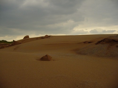
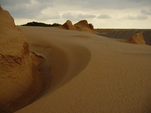
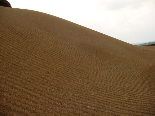
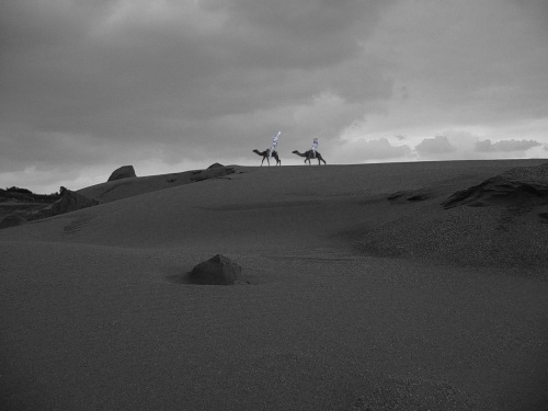
These are a collection of photos taken a few years back of the sand deposits in the quarry on Hopwas Hill behind the Lichfield Transmitter mast taken at the dawn of the digital camera age. I remember it was my brother´s great  idea to take up close up pictures of the dunes, capturing miniature desert landscapes. As quarries are constantly constructing and destroying landscapes, I don´t know what appearance it would have now but the quarry is still there in full swing.

The quarrying activity reveal and resurrect or at least evoke long dead landscapes. The sands and rounded pebbles in the area, so sought after by the quarries come from Triassic deserts and river deltas(250-200 million years ago). This is information I remember from geography lessons at school, so might not be entirely accurate but definitely made an impression on me and is now part of the story of the place for me( corrections are welcome).

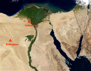
Go back hundreds of millions of ago and find yourself surrounded by giant river delta in a desert setting reminiscent of pre-human Egypt maybe.

Tamworth Timehikes 250 million years ago

If you can´t do that find the next best thing and that´s taking a look and immersing yourself in the prehistoric landscapes created by the quarry. Below is a winding river in the desert created by the quarry, ideally with some large reptiles in the background.

Below are the photos of Tamworth timehike´s very own desert. There windows into a very ancient world, the oldest visible landscape in the Tamworth timehikes area, as well as some of the newest. The sands from those primordial times having  a brief second life. Triassic sands again are being exposed to the elements and set free.

Below an oasis on the horizon

Abe and Ernst couldn´t resist the  One thousand and one nights setting on their doorste.

There was  something of The Planet of the Apes, Forbidden zone about the place too

Read Full Post »

My posts are pretty non-existent at the moment, even slower than usual. I´m a bit overwhelmed at the moment hope to get back to more Abe and Ernst adventures and musings in the macro-macro world of tamworth timehikes soon. Meanwhile I´ll leave this post as a bundle of links about online maps and tools used in Tamworth Timehikes that can be used equally in other places in UK for having a deeper look at the landscape´s history.

Abe and Ernst taking time out from Timehikes

Some possible future and past routes around the area

Well first you´ve got online maps.co.uk. They´ve recently updated their site and have now got maps of the UK from around 1888 to the 1970´s including Soviet cold war maps! It´s got a nice map based search interface too. Staffordshire Past track has got a search map section with Yates 1775 Staffordshire map on scale 2(pretty much the earliest close-up survey of Staffordshire) On scale 1 you´ve got the 1899-1903 ordnance map on view. On vision of Britain through time website you´ve got the Ordnance Survey first Series from the 1830´s. An extremely valuable resource is the British Library´s effort to upload the 1780-1840 one inch to a mile ordnance drawings. They are  beautiful maps and extremely useful in Tamworth Timehikes. I first came across the 1815 map from a link from the Building history map links section. It’s a pretty exhaustive list of map sources and worth taking a look at. Historical aerial photography for free is sparse on the internet at least for England, the situations looks different for Scotland. I think it has something to do with the Old aerialphotogaphy site having the rights! What we do have though is of course Googlearth satellite imagery. One of the great things about Googlearth is that you can toggle the dates on the images, in the clock button at the top. So you can get different images in Tamworth´s case back to far away days of the late 90´s. This is really useful for checking out cropmarks etc. Bill on comments recently pointed out Flashearth, Microsofts satellite imagery platform. The images seem to have been taken at just or almost the right time of year for spotting historical cropmarks, soilmarks, etc, really useful. Geomatics group have the LIDAR images up on the web , LIDAR is amazing see through trees imaging technology that´s revolutioning  Landscape archaeology.  Apart from this, different societies, initiatives, blogs have uploaded old maps, tithe maps, photography depending on the area. So go ahead and do some intrepid exploring from the comfort of your chair. Who knows the lost city of Z could be right next to the local Tescos.

Read Full Post »
This will get the American tourists coming in, come to Tamworth and see Robin Hood’ s Butt!

Well according to history of the town and castle of Tamworth, by Charles Ferrers Raymond Palmer, 1845 they were located nearby in Elford and Wigginton. I´ll stop going on and leave pasted  below this extract from the remarkable stories of Robin Hood and some “roman tumuli” in the vicinity:


Abe and Ernst who have been out of the picture for a while couldn´t resist testing out the theory that Robin Hood could shoot from one butt or ´prehistoric mound´  to another.

preparing to shoot

will it make it >>>————->

Read Full Post »

On this blog I´m often using material, especially maps from sites such as Staffordshire Past tracks, British library, and I´d like to take out some time to thank them and others for providing the material online without which blogs like this or other landscape investigation blogs wouldn´t be possible. To stop this  sounding  like an Oscar ceremony, there’s also the question of Copyright and legal issues when using other sources.  My mind turns to mush whenever I start trying to find out about legal issues. I´ve got fuzzy knowledge of non commercial use, copyleft sounds interesting but couldn´t maintain the attention span to get through it. There´s no problem with people using the material in the blog, but  it´s always nice to get a mention and I apologise if I haven´t mentioned all my sources, I try but  its something to improve. Anyway if anyones can sum up copyright and permission issues in a few lines with pretty pictures it would be greatly appreciated!

Is this legal?

Read Full Post »

Windmill Farm

taken from OS OpenData showing windmill farm and windmill Close, located on outer limit of Coton Green, Tamworth, click on for larger view.

This is the best candidates for Tamworth´s very own windmill. Moneymore mill is on the outer limits of this blogs area and windmill hill, Whittington is a big maybe.  Windmill´s being the major landmarks they are, leave echoes in the landscape in the form of names. They seem to smother the immediate surrounding area with the words windmill, for example the names Windmill lane, windmill hill, windmill pub. In this case we´ve got the name of the farm itself and the nearby windmill close as reminders of the presence of the windmill. The word windmill has even totally smothered the previous paragraph and the last few posts.

Below is the 1815 ordnance map(taken from British library) with the windmill symbol. In the symbol it appears to have 4 sails, was this a standard windmill symbol or did the cartographer depict the real windmill(probably the former case)? Can´t find  no written  information on the windmill. The only mention is an entry in English Heritage´s pastscape site mentioned  as a windmill mound with the tag post-medieval, although there´s no sign of that either.  The guess is that it was a brick tower windmill like most in the West Midlands.

Below is my  (amateur)  mock-up of what the windmill would have looked like if it was still around, with the back drop of Windmill farm, coton green. The windmill stood at the crossroads of Comberford road and Coton lane

Below is the 1837 ordnance map (from vision of Britain) with the windmill again featured with four sails. The next maps I´ve seen in the area are 1888 ordnance maps and there’s no sign of the windmill. So can surmise that it disappeared at some point between 1837-1888.  In the map below you can make out its location next to the present day Lichfield road, as mentioned before there´s no sign of  a  mound in this exact location( even on Lidar images) so its been ploughed under or I´m looking in the wrong location.

Abe and Ernst wanted to have a look around to get a feel for the place and see if their were any reminders of the windmill. The problem prone pair had a run in with the farm guard dog and just managed to get on the fence.

Read Full Post »

With the whole Don Quijote theme running through the last posts it seems appropriate to put this link to a great new idea in theory from Spain to participate in reading out loud the Cervantes classic Don Quijote on youtube(I think in Spanish). It’s a hefty  book and anything that makes Cervante´s all time classic more accessible is welcome.

Moneymore mill(formerly known as Weeford Mill, formerly known as Canwell mill)

In the quests for windmills, this is one of the furthest locations Ernst and Abe will  have to travel in Tamworth Timehikes, it’s located to the south of Weeford(look for the windmill symbol in the present ordnance map below)

This has got to be one of the top 10 strange locations for a windmill, smack bang in the middle of a working quarry. Don´t know how they did it, but somehow someone managed that the tower survived in the midst of quarry HQ. With the dilemma of how could they get the pictures of the place ( they couldn´t ask for obvious reasons ) Ernst and Abe paraglided over the quarry and managed to take this picture below.

taken from  http://www.multimap.com

To get in closer Abe and Ernst decided on using one of the bulldozers as cover, in all the excitement they didn´t  take any  pictures, a poor excuse.

According to Windmill World , it was first mentioned in 1818 and consists of surviving windmill tower. Taking a look at the first ordnance survey map below  of the area, dated to 1817, it´s clearly marked out as Canwell Mill(map taken from british library website).

Did it have any relation to nearby Canwell hall, which was previously the site of the medieval Canwell priory? Priories were working institutes and would often have a ‘mill’ in their property. The mill itself was from the late 18th/early 19th century, connection to an earlier mill is pure  conjecture and can´t find anything out there.   Apart from that  according to English Heritage it was used as a  flour mill.

Below is an image of Reads Flour Mill in nearby Burton, demolished in 2000, to give an idea of a functioning mill in the area. The image is  taken from Staffordshire past track.

Read Full Post »

The first adventure for Abe and Ernst is aptly going to be to do with windmills, Don Quijote´s giants in the landscape. Ernst and Abe are not going to have much luck in finding windmills around Tamworth, as there isn´t any. Tamworth being crisscrossed by rivers was ideally suited for watermills.  There were though at least a couple of windmills nearby in the not too distant past, with one more ‘maybe’ windmill.

Windmill Hill, Whittington

This is the ‘maybe’ windmill. In the fields between the village of Whittington and Hopwas  stands Windmill Hill, at the end of windmill lane( in the above present day ordnance map its marked in orange, notice the firing range nearby…

Abe and Ernst doing the research in the reference part of Tamworth library, there´s wasn´t much out there, basically there´s just the 1899-1903  ordnance map below with windmill hill marked. Thats about it that´s all there they have to go on. It´s a great location for a windmill but its not recorded in any map dating it as far back as 1815, so either  there was a windmill here before that or it was wishful thinking when it came to naming the hill.

I wonder if Whittington History Society know more about it?

Windmill hill is at one of the highest points in the area, and would have been seen for miles around like a smaller version of the present day Lichfield transmitter mast, if it did indeed exist.

The 1899-1903 ordnance map with Windmill Hill clearly marked, is the associated windmill lane some sort of remnant path? did it once lead to the windmill?

Abe and Ernst tried to check these questions and more out on the ground. The bad news is that there´s a firing range nearby used by the military and they were caught in the cross-fire. Will they survive? you´ll have to wait…………………….

Read Full Post »

Older Posts »