Feeds:
Posts
Comments

Posts Tagged ‘trees’

A single oak tree

Spring has started so fitting to go back and renew  this blog which I´ve abandoned over the last few weeks.

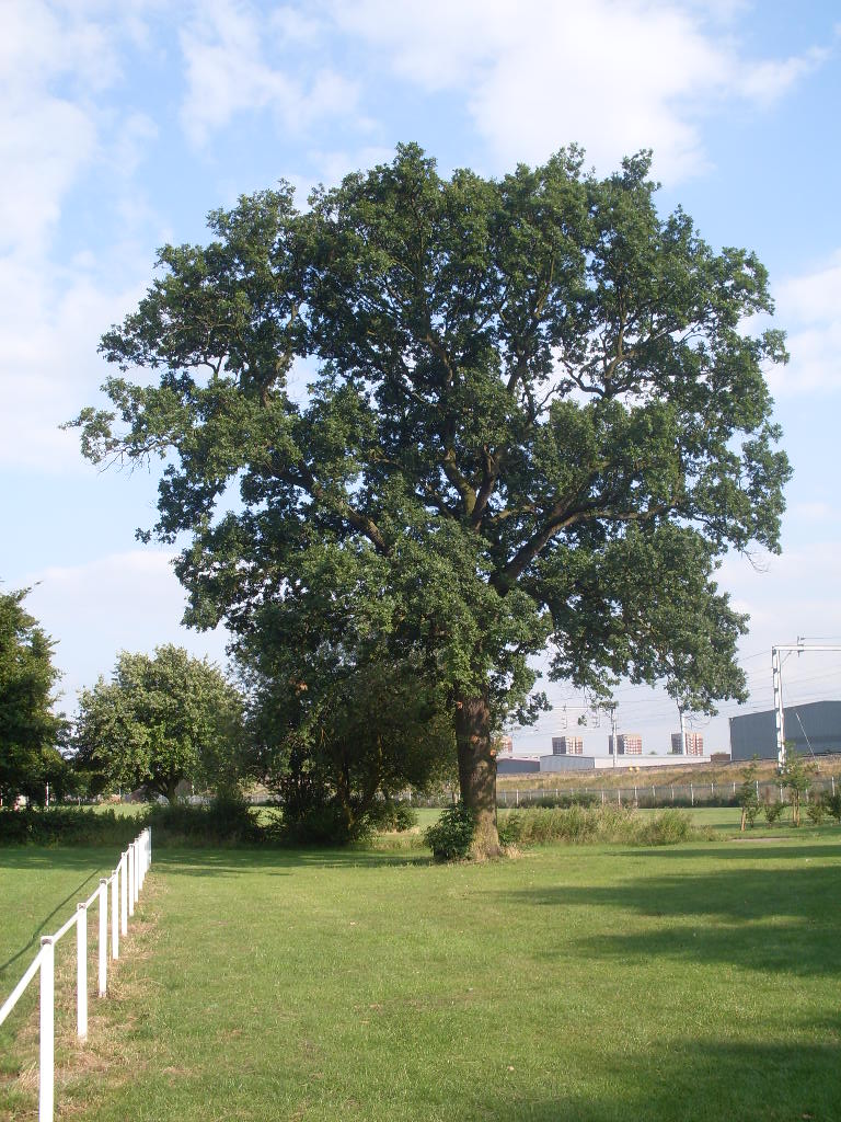
continuing with the very delayed  ancient tree series on Tamworth, came along what must be one of the oldest trees in the area. An oak tree well hidden among a hedge between the river Anker and the Ashby road. With age it´s shrunk and taken on a hermit like existence alone among a hedgerow crouching even further down to avoid passersby.

the tree in question on top right, mimicing the surrounding hedge.

I interrupted on its solitude last Summer finding it after scouring the usual 1899 maps from Staffordshire past track. The surveyors  had even gone to the trouble to include notable trees in the area marking a handful of elm and oak trees in this area.  Trees marked would have considerable age or be distinctive in some way so any survivors to the present day warrant  at least a passing  look.

1899-1904 ordnance map from Staffordshire past track showing the oak and now disappeared  elm trees

The oak is the only survivor I could find in the area from the 1899 maps. It´s in bad shape, looks like it might have weathered more than a few storms. Its advanced state of disrepair, trunk mummified in ivy only adds to it´s potential age, although on the other hand it´s trunk isn´t the widest and it´s lost it´s crown so it´s not the largest oak around. It looks like it hasn´t been looked after by humans for a while at least. Oaks on average can live to around 300 years how old without coppicing . How old was this one? Was it around when the Earl of Richford´s forces passed nearby to the battle of Bosworth 1485?  hmmm don´t think so but gives me a chance to include random image of King Richard III.

If I´d known about the hugging technique to age trees well that might have solved the oak´s age there and then. Intrigued well look at this manual from the Woodlands trust.

On the subject of manuals

In a constant search to give this space meaning I´m going from now on to put an emphasis on providing  ideas, different ways of looking at our surroundings and knowledge/tools on how to explore, , interact, discover and ultimately enjoy landscape history both rural, urban and in between  in England, using Tamworth as an example of course.

That’s a pretty big benchmark and would be fantastic to hear from other budding amateur landscape historians, artists, canoeists, dog walkers, tree huggers, archaeologists on the different ways  and takes to do this.

Read Full Post »

On my search for ancient and venerable trees in the Tamworth area I came along this from the endless resource of Charles Ferrers Raymund Palmer´s book on Tamworth. When Charles focused on a building, boy did he focus on it, his writings on the Moathouse throw up all sorts of info as if gone through with a comb. About the trees in the long drive he´s got this to say:

“The moat house is a very large and handsome structure,……………It is approached from Lichfield street through a long avenue of noble lime-trees, of more than a century´s growth.”

The mentioned lime trees are still there and if we go by the tree´s estimated age written by Charles in 1845 that makes the trees more than 275 years old!!

The moathouse with Lime trees on either side

Knowing little about  trees I quickly googled info on Lime trees and found out that they´ve got nothing to do with limes, can indeed be very old, and you can use the flowers to make a tea for medicinal purposes, old flowers apparently having narcotic effects hmmm, interesting. The idea of using the fruits from a 270 year old tree sounds appealing to me, actually the whole idea of drinking something with great age is appealing although not the same check this out about oldest champagne found and tasted.

Anyway to know more on Lime trees known as well as tilia(the genera) take a look at this and this.

a lime tree(tillus) image with details, click to go to the link

I´m in Tamworth so will duly insert some photos of the brooding moathouse expertly framed by the Lime trees, shame I´m not the best photographer in the world, but just maybe, maybe this once.. Watch this space.

Read Full Post »

Adding trees

A number of factors have induced me  to write this new series adding trees, especially old trees to the Timehikes blog(might even get round to adding people at some point!).

Firstly the Government crazy woodland sell off and the campaign to stop it, there´s been loads of really good arguments against it, for example Outlandish Knights blogs entry and Brownhill Bobs view on  it here on the sell off.  I haven´t got much to add, just a paranoid observation from the truncated world of Tamworth Timehikes that  the recent government´s backtracking  got me thinking that this maybe was the half-baked schemes real aim. They didn´t really think that it would work did they without huge opposition  ? Maybe it was to look like the government was ´listening´ to the people on this high-profile case, a sort of smokescreen.  Maybe I´m giving them too much credit..

Then there´s a series of post´s on Brownhills bobs blog, about the Shire oak tree, an ancient emblematic  tree that once stood in the  Stonnal area which exemplies to me  what collaborative history detective work could really do for a place, uncover, enrich with stories and memories.

Also I´ve been wanting to put a tree themed post about this for a long time.  I´m rubbish at identifying trees, get the names mixed up but I recognise trees, especially old trees are very special awe inspiring living things, unique ecological niches . There´s a great citizen science project called the Ancient tree hunt from the The Woodlands Trust, worth taking a look at.

Finally recently saw  this article in the herald about the history of Gungate road formerly known as Old Stony road. In a great bit of detective work  from Paul Barber and the article’s author(can´t find the name in the article)they recognised that a beech tree in an 1829 engraving incredibly survives till today.

This serves as a perfect introduction to ancient trees in the Tamworth area. All credit I stress for the discovery goes to the authors of the Herald article. I´m just adding the pretty pictures.

Taken from Staffordshire past track. the Engraving mentioned from 1828-29 from E.B Hamel, north view of Tamworth from Gungate. The Beech tree is on the left. In true  romantic style the scene has been given a bit of drama by enlarging the church and castle complete with fluttering flag. With some added farmer folk in the forground.

The contemporary 2010 scene, courtesy of the google streetmap car.  The Tall copper beech tree is still there on the left in the garden of Mayfield house, on the corner of croft street.  The tree´s got bigger, while the church has got smaller!

Read Full Post »

Continuing with the earlier post, Before Suburbia, I´m moved along the lost driveway onto Wigginton park, the great big park in the middle of the housing estates of Coton Green and Leyfields, Tamworth. It’s a great monument to the pleasure of grass. When I´ve visited Tamworth with a foreign acquaintance, I only take off their blindfold at a select group of places, including the castle grounds, library/ church and yes Wigginton park, its safe to say they are suitably impressed by the gently sloping park with it´s almost lurid greenery.

Well there´s the introduction, now in the words of the great George Clinton “let’s get deep, get real deep” For reasons of time and sanity,  I´m going to split this  into 2 posts, this one DEEP and the next one REAL DEEP, each  going deeper into Wigginton park´s  past. So here goes

DEEP

Wigginton park conforms approximately to the former Wigginton estate.The information on the estate below  is essentially a reworking of what´s on  Tamworth heritage trust site The Wigginton estate was created at the beginning of the 19th century by John Clarke and his wife Elizabeth. They let the area revert to grass and planted trees, designing the area as a pleasant park. They built a couple of lodges one at the end of Copes drive, now near the Leyfields shops and one called Waterloo  on the western side close to the railway tunnel entrance to Lichfield industrial estate. No evidence remains of them and looking at maps appear to have been demolished in the first part of the 20th century. What does remain is their main residence, nowadays called Wigginton lodge, home of Tamworth rugby club and pub! although never been in there. It´s an attractive white mansion, detailed technical information can be found on the english heritage site. John Clarke an eminent surgeon died in 1815. His brother Charles Clarke inherited it soon after. Like his brother Charles was a surgeon, specialising in children’s ailments. He went onto achieve great fame in the field and became personal physician of Queen Adelaide, wife of King William IV. After his death it was sold to the Hamel family. Its auction in 1852 appears in the Solicitors journal, published online. I´ve pasted it below, giving you an idea of life in Wigginton lodge at the time, I love the bit about 3 hours train journey away from London.

Apart from the mansion (above) , and the park itself there’s number of other reminders of the estate’s past.

Above is the 1889 ordnance map with some of the places mentioned in the post pointed out in orange

A lot of the trees would have been planted at the time of it´s creation and after. There´s a particularly leafless creepy example. which seems to be some tree version of the living dead. I´ve got no pictures of it, instead I´ve got one of the tree above that’s probably judging by its age a mute witness to the Waterloo lodge that once  stood next to it.


Above is an old gateway with detail on right, situated next to the original mansion.

The evidence of gravel pits is still there as they appear on the 1884-85 ordnance map. Interestingly the biggest gravel pit as are others in Hopwas are locally known as bombholes. The connotations are a lot more interesting than gravel pits and makes you think of a Lufwaffe pilot gone astray and bombing  Wigginton park, with one hell of a bomb by the looks of the hole. It’s another urban legend in the making, so make sure to tell the kids the´re called “bombholes”


Above, Theres no evidence of the paths that crisscross the estate on the  1901 ordnance map today. Putting the clock back on the google earth image to 2003 though, the genuinely elusive paths are revealed(pointed out with orange arrows)! probably after a dry summer.

There´s more, that I didn´t get a chance to check out over summer. For example on the 1884 ordnance map, an icehouse and saw pit are indicated, is there any evidence  left now?

Read Full Post »

This is first in a series of posts  looking at evidence of  BS(before suburbia) pasts  within the housing estate, focusing on Leyfields, Tamworth the estate I grew up in. Travelling along Comberford road in direction to Elford, you´ll come across a drive to the left called Copes drive, it’s an unkept road at the start, full of potholes, the result of some sort of impasse probably between owners and local authorities. It’s the road that I used to use to travel to school as the shortest way to school from Leyfields. Its turns out that this shortcut has  a long history. It’ s  a remnant path or elusive road(fascinating description on Geoff´s BLDG blog), an anomaly remaining from another time, stubbornly refusing to go away.  You can find these ´lost reminders of past built environments´throughout suburbia and I´ll post about other ones found.

This unassuming drive  goes back to at least the late 1700´s(its lost in the mists of time before that, to me anyway), it’s called Copes drive in reference to the owner of the land in the late 18th century Alexander Cope. Later on it was the main thoroughfare to the  Wigginton Lodge estate belonging to distinguished surgeons  the Clarkes.  After Leyfields housing estate was built in the1950´s/60´s it was begrudgingly incorporated into the housing  estate .

Ordnance survey first series, 1834 clearly showing Copes drives connecting Wiggington lodge with Burton Turnpike road(now Comberford road)

The hedge on one side at the start, and the recently sawn down tree at the start are reminders of its age. This part of the drive  with its pot holed surface , is an accidental nod to its ancient pre-tarmaced days.

1902 ordnance survey map, with the surviving Copes drive highlighted. Notice that it´s the first part of the entrance to Wigginton lodge

If you carry on down Copes drive, leave it and cross onto the green which heads to  the famed Leyfields Chippy and former hangout of the defunct Leyfields Barmy Army gang of local legend, you´ll notice a line of horse- chestnut trees. After braving the long grass perfect for hiding dog shit, the trees magically line up in two rows revealing the remnants of  the old tree-lined drive smack bang in the middle of the killing fields of Leyfields! I don´t know much about dating trees but I could imagine them being easily over a 100 years old. The fact that they are all horse-chestnut trees and all look around the same age, leads to think they were deliberately planted at the same time along the drive. Walking in the middle of the row you can see shallow holes where other chestnut trees once were. Theres no path between them now but the trees mark the spot and the walk to the shops will never be the same again.

the tree-lined remnant path.

extremely detailed 1902 ordnance map, with the  tree-lined drive highlighted.

google satellite image with evidence of tree-lined drive highlighted in orange.

Read Full Post »